Sunday 27 September 2015

Allez! Allez! Allez! II

Hautacam

Height 1520m Ascent 1040m in 13km Average gradient of 8%

We made our way to Argelès Gazost, up to D100 to the carpark of Carrefour Argelès Gazost. There were several big groups of cyclists on the same road so we knew we were on the right direction. While Iain had a head start, I went into Carrefour to get food (I love supermarket shopping!)


After conquering Col du Tourmalet, Hautacam is "small" challenge, but by no means less formidable.

Hautes-Pyrénées
(Source: http://www.letour.com/le-tour/2014/us/stage-18.html)

Hautacam was where Cadel Evans wore the yellow jersey for the first time in his career with a 1 second lead over Fränk Schleck in 2008. In 2014, as the penultimate stage, the steep slopes of Hautacam provided the perfect opportunity for Thibaut Pinot to attack and leapfrogged Alejandro Valverde to second place (or as Phil Liggett would have put it "Pinot was dancing on his pedals while Valverde stopped and cycled backwards").

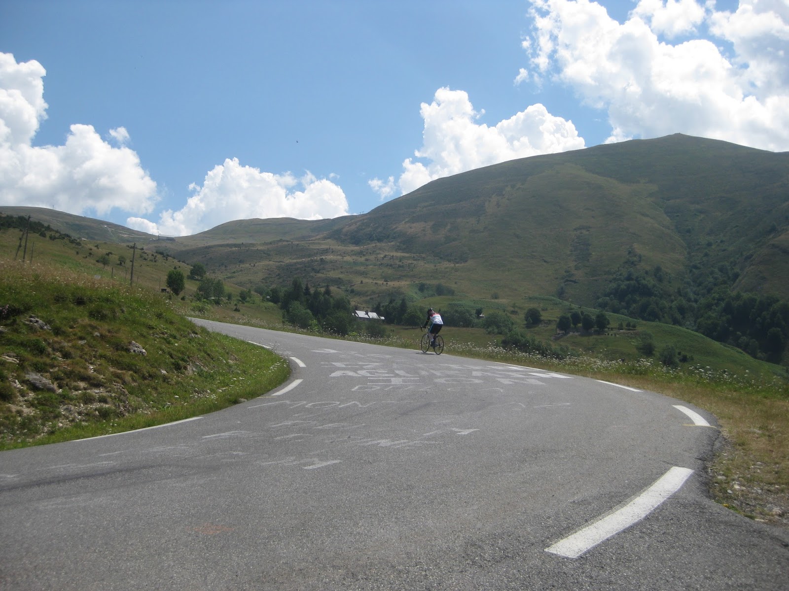
The first part of the route up Hautacam was shaded. I had a chance to stop by a tiny waterfall outside the village of Artalens-Souin and cheered whoever rode by.


With less than 7km to go, there was hardly any shade.

Iain cycling in the sweltering heat
The scenery was awesome nonetheless.
On the way up Hautacam
What is wrong with my bike?
At 1520m, one reaches the "summit" of Hautacam - the point where Tour de France mostly stops due to practical logistics reasons (such as a carpark and a big enough space to set up stage). There is in fact, still some way to go up to the summit.
Tour de France formally stops here

Mont Ventoux

Height 1912m Ascent 1690m in 21km Average gradient of 7%

From Tarbes, we bade farewell to the French Pyrénées and drove through Toulouse to Avignon. The mountains disappeared and we were greeted by old viaducts, castles and fields of sunflowers.

Field of sunflowers
The city walls of old Avignon
From Avignon, we reached out to the French Alps. Iain picked up his rental bicycle at Bédoin, at the bottom of Mont Ventoux.

Mont Ventoux is located between a Alpine massif to the north and Mediterranean massifs to the south. The bottom of Mont Ventoux has a mixture of oaks, pines and cedars and is home to golden eagles, viperine snakes and chamois, to name a few. Vegetation stops at about 1500m but 60 rare flora species manage to survive on the summit. In 1990, the rich and diverse flora and fauna microclimates and habitats of Mont Ventoux made it to UNESCO's list of protected biosphere.
 
(Source: http://www.unesco.org/mabdb/br/brdir/directory/biores.asp?mode=all&code=FRA+06)
Summit of Mont Ventoux and the meteorological station
Where the vegetation stops, the bald limestone summit loomed. Mont Ventoux's distinctive summit and now-defunct meteorological station have perhaps made it on every cycling magazine in the world. 'Ventoux' means 'windy' in French and the sun bouncing off the limestones would make the last stage of the ride really hot - a double whammy. We were really lucky it was not too windy when we were on Mont Ventoux. While is was hot, maybe it was because we have acclimatised, it was not as hot as we envisaged.
An old road marker
There were a lot of cycling enthusiasts as usual, with a good mix of young upstarts and old. In addition, joggers and some novices (such as children in their small bicycles who had to be pushed up the hill by adults and others who could not keep to one side of the road and had to zigzag up the slopes) made driving really precarious. In 1990, it was estimated about 600,000 people cycled up the mountain each year (Source: http://www.unesco.org/mabdb/br/brdir/directory/biores.asp?mode=all&code=FRA+06).

In the initial stage, the trees provided some respite from the heat. Soon, the bald summit appeared and taunted us from afar.

Another slog up the the bend with Mont Ventoux taunting from afar
Exercise prudence - 'cos that's how steep it is
So near yet so far


I am not sure if it was because we were closer to the Tour de France or the bigger turn out as compared to Col du Tourmalet and Hautacam, I could not help but feel that there were also more arrogant cyclists on Mont Ventoux – them in expensive gears, do not acknowledge when you cheer them on and tear down the mountains in top speed. I could not see any reason why there is any need to put one’s life at risk by going downhill and around corners at more than 80kmph when professional cyclists misjudge corners and go over barriers. Surely not everyone is a Romain Bardet making a lone breakaway with the whole peloton chasing him down.

Allez! Allez! Allez?

No. Chill, people. Chill.


Saturday 5 September 2015

Allez! Allez! Allez!


Iain is an avid cyclist. Having conquered Alp d’Huez previously, we had planned for him to attempt to ascend 3 hors catégorie ("HC" or exceptional) mountains in the French Pyrénées and French Alps, made famous in the world of cycling by Tour de France. 

Logistics

The logistics involved in travelling around the Pyrénées and the Alps is surprisingly complicated. Firstly, we found out that in order to fly from one city/town to another, one has to transit in Paris - this means a lot of detours and waiting at the airports. If we were to take the trains, it will often take multiple changes and more than 6 hours to get from one town to another (for example, it takes 2 changes and 6 hours 11 minutes to get from Tarbes to Avignon). In the end, after doing a lot of research on flights and train timetables, we decided to rent a car from Tarbes to Grenoble. But alas! No thanks to le Tour and the summer holidays, most car rental companies have run out of options 7 months before our trip. Thankfully, we found a compact automatic car at a reasonable price (4 months later, the same car from the same car rental company has almost doubled in rate).  

While I was researching for a car, Iain was checking out the bicycle rental options. As we were arriving after the Tour de France teams have passed through the mountains, renting a bicycle was not too much of an issue. Iain rented a bicycle at Saint-Savin, a tiny village not too far from Argeles-Gazost, to climb Col du Tourmalet and Hautacam. Next, at Bédoin, foot of Mont Ventoux, he was able to find another bicycle to rent.

How does one know he is in the Pyrénées?
Just look up and one will see birds of prey spreading their wings and soaring effortlessly in the sky,
at times circling, at times swooping, sending shivers down one's spine 


Col du Tourmalet

Height 2115m Ascent (from Sainte-Marie-de-Campan) 1275m in 16.9km Average gradient 7.5%

We picked up Iain's bicycle first thing in the morning and drove to Sainte-Marie-de-Campan, our starting point. (Having said "first thing in the morning", we had underestimated the time required to drive from our hotel in Tarbes to Saint-Savin, pick up and set up Iain's bike then drive to Sainte-Marie-de-Campan. By the time Iain started his ride, it was past 11am on a relentlessly hot summer day.)

Church of Notre-Dame-de-l'Assomption, Sainte-Marie-de-Campan

Sainte-Marie-de-Campan is most famous for its association with Eugène Christophe. in 1913, while riding down Col du Tourmalet during Tour de France, the fork of Christophe's bicycle broke. As the rules of the race prevented him from receiving outside help, he had to walk more than 10km with his bicycle on his shoulder, then weld his fork at a blacksmith at Sainte-Marie-de-Campan. Suffice to say, he did not win the Tour that year. In 1919,  Christophe became the first man to wear the first ever maillot jaune (yellow jersey) when it was introduced (Source: http://www.letour.fr/le-tour/2014/us/history/).
Statue of Eugène Christope (1885 - 1970) and his fork by Yves Lacoste,
starting point of the climb

Col du Tourmalet was first included in le Tour in 1910, when Frenchman Octave Lapize first went over the high mountain pass and went on to win the Tour that year. “The television makes the roads look flat”, Iain has always said this when watching the Grand Tours on television. I finally found out for myself.
It sure does not look like a 10% gradient

The road leading up the Col du Tourmalet is steep and difficult to drive. Coupled by the fact that this was the first time that I drove on the “wrong” side of the road and more importantly, up a mountain, going around the bends with cyclists and cars on both sides of the roads was certainly nerve wrecking. It is probably 10 times worse for a cyclist. 
Directrice sportif/ soigneur/ cheerleader/ camerawoman in action
After a sun-exposed ride from Sainte-Marie-de-Campan, one reaches the ski town of La Mongie. Further afield, the final 5km of merciless and steep road awaits.
The last 1.5km
Cycling past the names of Contador and Uran(?)
On top of the pass, Octave Lapize's statue awaits. After a 1275m ascent, it must be a relief to most cyclists to finally see his bum.
L: Every cyclist cannot wait to see Lapize's bum
R: Statue of Octave Lapize

On top of the pass is a restaurant and a very crowded souvenir shop. I am not sure if it was because we descended without breaks (and the car rolled down the mountain and easily picked up speed as a result), there were a lot of hairy moments during the descent to Luz-Saint-Sauveur (which also means that an ascent from this side of the mountain will not be any easier). Fortunately for me, a flock of sheep appeared on the road just as I began to descend and alerted me to the potential perils on the road (cyclists hurtling down at 80kmph, animals wandering across the road, dramatic drop off the road, switch-backs). Determined cyclists, red in the face from the heat and exhaustion, were peddling hard from the opposite direction. Allez! Allez! Allez!


Baaaa...